
Naver Maps, which has the highest number of users in Korea, enhances the delivery of traffic safety information on the map to provide users with a safer and more convenient travel experience.
Naver announced on the 17th that it has conducted a new update for Naver Maps, which delivers detailed accident information occurring within users’ living areas and strengthens disaster information guidance during navigation.
This update is a continuation of Naver Maps’ recent series of enhancements related to user travel support services. Notably, these include ▲ Public transportation guidance service ▲ Real-time public transportation guidance without opening the app through iOS live activity feature ▲ Avoidance route guidance for users having difficulty using stairs ▲ Driving score feature that analyzes user driving records to score driving habits, among other functions that have been consecutively introduced to enhance user mobility over the past several months.
As a result, the number of active users (MAU) of Naver Maps’ public transportation and navigation functions has consistently increased, leading to an overall rise in the app’s MAU. In fact, it has been confirmed that the overall MAU of the Naver Maps app has increased by about 15% compared to last year. Therefore, Naver Maps has further strengthened information guidance related to various risks occurring on roads to support safer travel experiences in addition to user convenience.
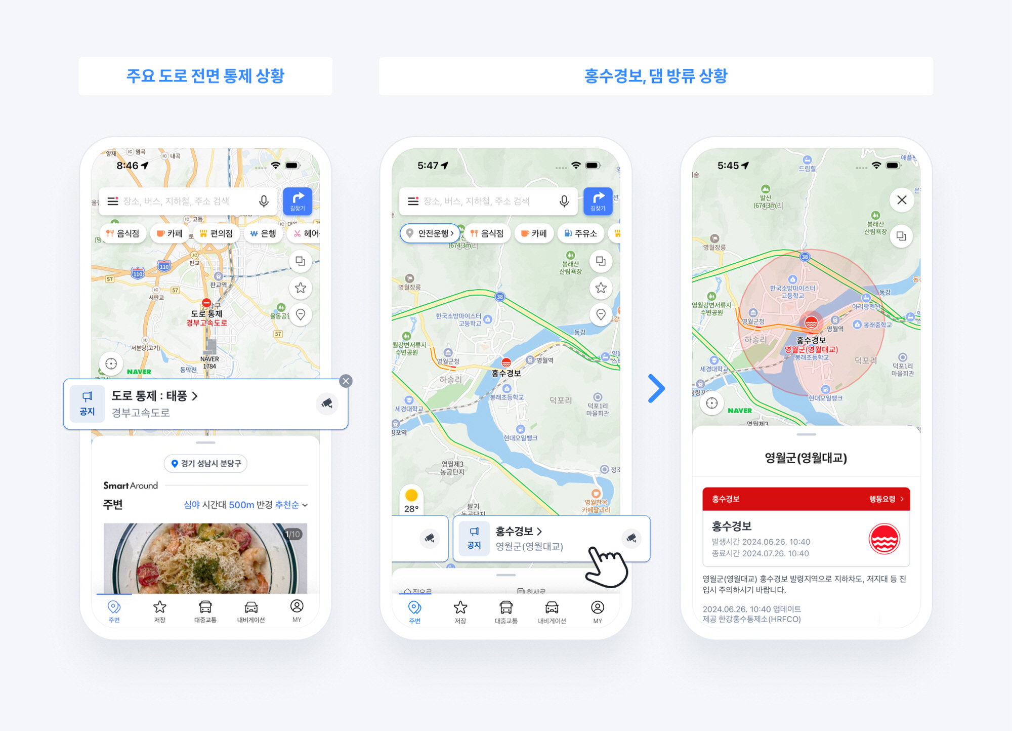
Accident information refers to various incidents that occur on the road, such as road closures, construction, traffic accidents, and disasters. Naver Maps uniquely provides accident information based on registered home or company information or the administrative district of the current location. It collects various information through municipalities, various administrative agencies, real-time news, and user reports, summarizing it so that users can verify it in a timely manner through a card format.
The card includes information about the control of major roads and bridges due to accidents or disasters, as well as information on service interruptions or delays at subway and train boarding stations. Users can check the details of events and the areas where they occurred at a glance through the information card, and they can also directly view the site situation through a representative CCTV connected to the incident location. Selecting the card takes users to a detail page that provides specific incident information, including a description of the incident and its occurrence and end times. For disaster incidents, a link to Naver Encyclopedia disaster response guidelines is provided to assist users in their response.
Naver Maps has also newly added disaster alerts such as flood warnings and dam release notifications, reconfiguring the existing four types (traffic control, accidents, constructions, others) of accident information icons into seven types. The restructured icons are highlighted on the map for better visibility, making it easier for users to recognize. Furthermore, control information about roads and subway stations that was previously available only by activating the traffic information button is now provided by default. The control areas, including traffic facilities such as bridges, tunnels, and underpasses, are indicated on the map with red dotted lines for easy user recognition.
Additionally, to help users consider regions with flood warnings and dam releases in their vehicle movement route planning, these areas are marked in advance on the navigation route lines. Sudden situations during driving are also communicated in real time to users. Risk information along the route is provided at the top of the mobile navigation screen, and auditory alerts are also given for incidents occurring near the incident points.
Choi Seung-rak, the leader managing the Naver Maps service, stated, “Unpredictable incidents pose a threat to the safety of pedestrians and drivers, and our goal for this update is to enhance the delivery of traffic safety information through Naver Maps to help users prevent accidents, drive safely, and manage their schedules efficiently,” adding, “In the future, we plan to continuously enhance Naver Maps as an ‘all-in-one platform’ that provides convenient and sophisticated travel experiences while supporting users throughout their journey.”
Lee Sang-jin daedusj@autodiary.kr